> ## Documentation Index
> Fetch the complete documentation index at: https://docs.valar.space/llms.txt
> Use this file to discover all available pages before exploring further.
# Ground Stations
> Create and edit ground stations with a coordinate minimap and one exclusive coverage-definition choice
> For the complete documentation index, see [llms.txt](/llms.txt).
The **Stations** page is where you manage the ground stations your organization tracks passes against. Each station has a fixed location and one coverage definition — either a constant minimum elevation or an uploaded elevation mask — that determines when a spacecraft counts as visible from it.
**Route:** `/passes/stations`
Open the page via the **Stations** tab in the Passes area's tab bar, alongside the **Table**, **Timeline**, and **Coverage Map** tabs.
## Page Layout
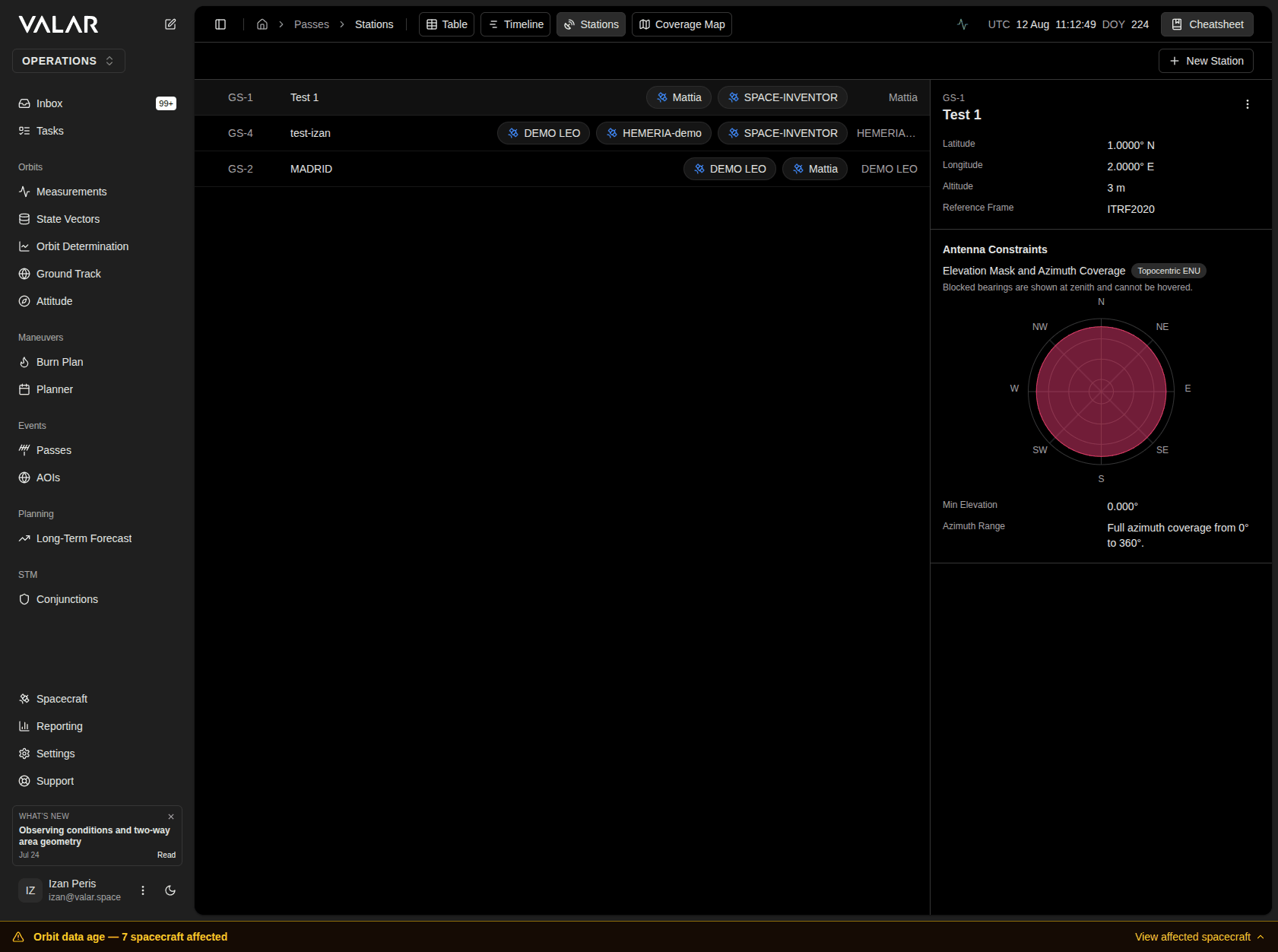 The page is a two-pane layout. The left pane lists every station in your organization; the right pane shows the details of whichever station is selected. Click a row in the list to select it — its coordinates, reference frame, and applied horizon appear on the right (see [Viewing a Station's Applied Horizon](#viewing-a-stations-applied-horizon) below).
Click **New Station** in the top-right corner to open the [ground-station creation modal](#creating-or-editing-a-ground-station). Selecting a station and opening its kebab menu (**⋮**) offers **Edit Station** and **Delete Station**.
When your organization has no stations yet, the page shows **No ground stations configured** with an **Add Ground Station** button that opens the same modal.
## Viewing a Station's Applied Horizon
Selecting a station shows its **applied horizon** on the right — the composed curve pass computation actually uses, alongside the raw survey behind it and your configured minimum elevation as a reference line. See [Elevation Masks](/features/passes/elevation-masks) for how these combine.
| Situation | What you see |
| ------------------------------------------------ | ---------------------------------------------------------------------------------------------------------------------------------------------------------------------------------------------- |
| **A surveyed elevation mask is on file** | Two curves: the applied horizon (dominant) and the raw survey behind it. Wherever the two coincide exactly, a note confirms it, so a single visible curve is never mistaken for a missing one. |
| **No elevation mask is on file** | A single curve at your configured minimum elevation. |
| **This station's stored horizon cannot be read** | **No horizon available for this station** — no chart is drawn, and no engine-applied curve can be shown until the survey is re-uploaded. |
| **The station's details failed to load** | **Failed to load this station's horizon**, with a **Retry** button. |
Beneath the chart, two rows describe the horizon in force:
| Row | What it tells you |
| -------------------- | ---------------------------------------------------------------------------------------------------------------------------------------------------------------------------------------------------------------------------------------------------------------- |
| **Horizon in force** | The angle currently governing this station. If your minimum elevation is what's actually binding — the survey would have allowed lower access but your policy floor doesn't — this is called out explicitly rather than left for you to work out from the chart. |
| **Horizon basis** | Where the applied horizon comes from: **Surveyed** (from an uploaded elevation mask), **Platform default** (no survey on file; a uniform horizon derived from your minimum elevation), or **Unspecified** (see note below). |
**Unspecified** does not mean something is wrong with the station. It means the station was configured before VALAR began recording where a horizon comes from, so its provenance was never captured — not that a survey is missing or that the platform is guessing.
A line beneath these rows may also state whether the horizon has been applied yet: for a station whose survey was just uploaded but hasn't yet been used in a pass computation, it reads **This horizon is on file but has not yet been applied to any pass computation.** Once it has been used, the same line instead reads **Horizon in force since \**.
## Creating or Editing a Ground Station
The page is a two-pane layout. The left pane lists every station in your organization; the right pane shows the details of whichever station is selected. Click a row in the list to select it — its coordinates, reference frame, and applied horizon appear on the right (see [Viewing a Station's Applied Horizon](#viewing-a-stations-applied-horizon) below).
Click **New Station** in the top-right corner to open the [ground-station creation modal](#creating-or-editing-a-ground-station). Selecting a station and opening its kebab menu (**⋮**) offers **Edit Station** and **Delete Station**.
When your organization has no stations yet, the page shows **No ground stations configured** with an **Add Ground Station** button that opens the same modal.
## Viewing a Station's Applied Horizon
Selecting a station shows its **applied horizon** on the right — the composed curve pass computation actually uses, alongside the raw survey behind it and your configured minimum elevation as a reference line. See [Elevation Masks](/features/passes/elevation-masks) for how these combine.
| Situation | What you see |
| ------------------------------------------------ | ---------------------------------------------------------------------------------------------------------------------------------------------------------------------------------------------- |
| **A surveyed elevation mask is on file** | Two curves: the applied horizon (dominant) and the raw survey behind it. Wherever the two coincide exactly, a note confirms it, so a single visible curve is never mistaken for a missing one. |
| **No elevation mask is on file** | A single curve at your configured minimum elevation. |
| **This station's stored horizon cannot be read** | **No horizon available for this station** — no chart is drawn, and no engine-applied curve can be shown until the survey is re-uploaded. |
| **The station's details failed to load** | **Failed to load this station's horizon**, with a **Retry** button. |
Beneath the chart, two rows describe the horizon in force:
| Row | What it tells you |
| -------------------- | ---------------------------------------------------------------------------------------------------------------------------------------------------------------------------------------------------------------------------------------------------------------- |
| **Horizon in force** | The angle currently governing this station. If your minimum elevation is what's actually binding — the survey would have allowed lower access but your policy floor doesn't — this is called out explicitly rather than left for you to work out from the chart. |
| **Horizon basis** | Where the applied horizon comes from: **Surveyed** (from an uploaded elevation mask), **Platform default** (no survey on file; a uniform horizon derived from your minimum elevation), or **Unspecified** (see note below). |
**Unspecified** does not mean something is wrong with the station. It means the station was configured before VALAR began recording where a horizon comes from, so its provenance was never captured — not that a survey is missing or that the platform is guessing.
A line beneath these rows may also state whether the horizon has been applied yet: for a station whose survey was just uploaded but hasn't yet been used in a pass computation, it reads **This horizon is on file but has not yet been applied to any pass computation.** Once it has been used, the same line instead reads **Horizon in force since \**.
## Creating or Editing a Ground Station
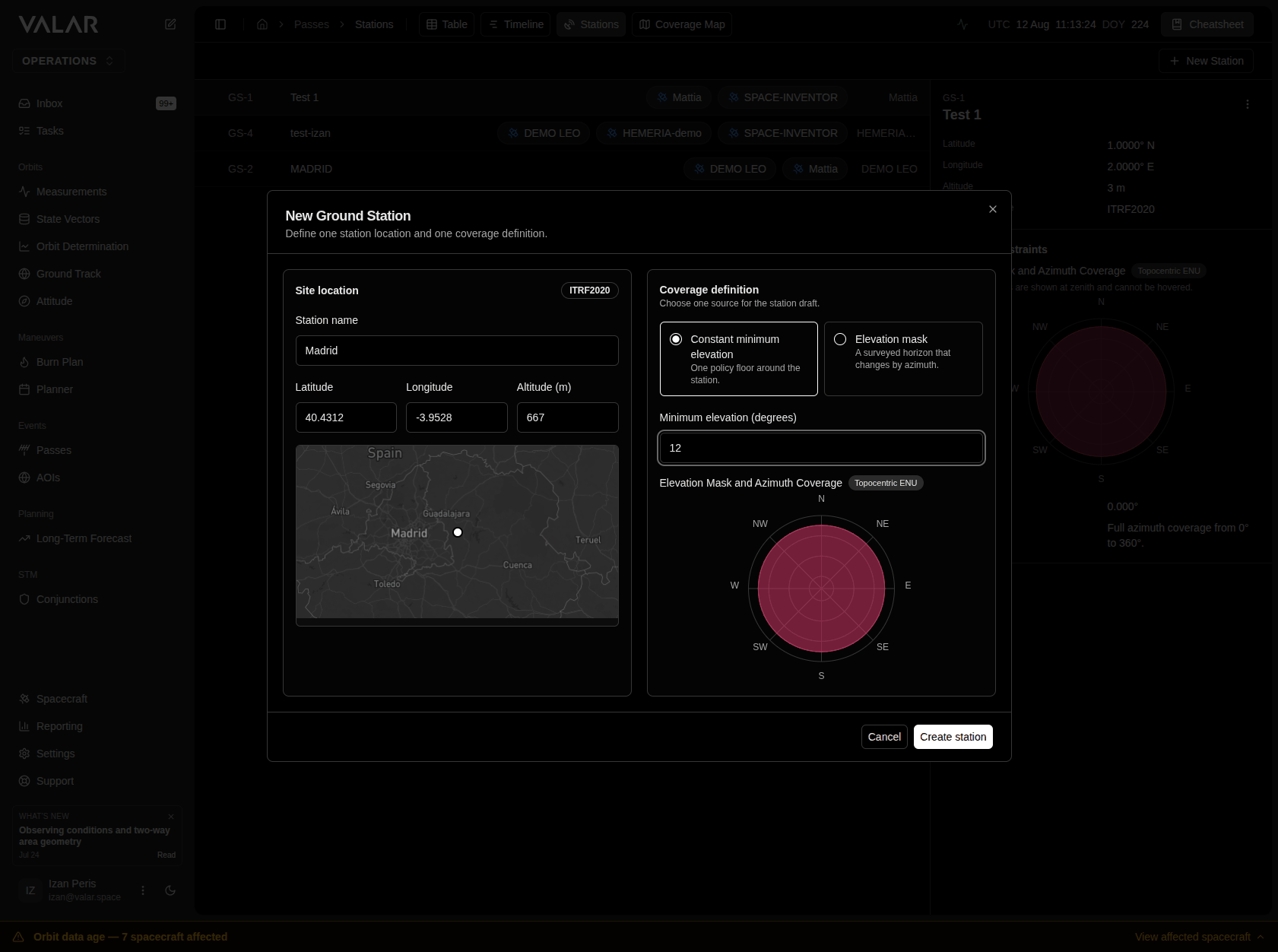 Creating or editing a station opens a single modal — **New Ground Station** or **Edit Ground Station** — with no next/back steps to move through. Every field for the station lives on one scrollable surface, arranged in two columns: **Site location** on the left and **Coverage definition** on the right. On narrower screens the two columns stack into one, so nothing here requires horizontal scrolling at any supported window size.
### Site Location
| Field | Description |
| ------------------- | -------------------------------------------------------------------------------------------------------------------------- |
| **Station name** | Free-text identifier for the station. |
| **Latitude** | Geodetic latitude in degrees, `-90` to `90`. |
| **Longitude** | Geodetic longitude in degrees, `-180` to `180`. |
| **Altitude (m)** | Station altitude in meters. |
| **Reference Frame** | Shown as a fixed `ITRF2020` badge next to the section heading — every station uses this frame; there is nothing to choose. |
Below the coordinate fields is a compact 16:9 minimap that places a marker at the entered latitude and longitude as soon as both are valid. It is a location check only — it confirms the point on the globe you meant, not terrain suitability, antenna readiness, or coverage.
| Situation | What you see |
| -------------------------------------------------------- | ------------------------------------------------------------------------------------------------------- |
| **Latitude and longitude are both valid** | A marker appears at the entered coordinates. |
| **Coordinates are blank or incomplete** | No marker; the map reads **Enter the station coordinates**. |
| **A coordinate is out of range** | No marker for that value; the field itself shows an inline error (see [Validation](#validation) below). |
| **The map cannot load** (no token, or WebGL unsupported) | The frame reads **Map preview unavailable**; the coordinate fields stay usable regardless. |
### Coverage Definition
The two coverage forms are alternatives, not two limits you combine — choose the one that describes this station's horizon and the modal shows only the fields that choice needs.
The right column holds one exclusive choice between two coverage definitions:
| Option | Description |
| ------------------------------ | ------------------------------------------------------------------------------------------------ |
| **Constant minimum elevation** | One policy floor around the station — the same minimum elevation angle applies at every azimuth. |
| **Elevation mask** | A surveyed horizon that changes by azimuth, supplied as a CSV file. |
Switching between the two clears whatever you had entered for the other — a mask you uploaded does not reappear if you switch back to it after selecting constant minimum elevation, and vice versa.
#### Constant Minimum Elevation
Enter a single **Minimum elevation (degrees)** value between `0` and `90`. A new station starts at `10.0` degrees by default.
#### Elevation Mask (CSV Upload)
Choose a CSV file under **Elevation mask CSV**. Each row is one `azimuth,elevation` pair:
```
azimuth,elevation
0,10
90,15
180,12
270,8
```
**Each row applies from its azimuth boundary until the next boundary** — a row does not describe a single point, it describes an interval. For example, `0,10` followed by `90,15` means 10 degrees applies from azimuth 0 up to (but not including) 90 degrees, where the 15-degree value takes over. The final interval wraps around from 360 degrees back to 0 degrees, so the last row's value also covers the gap back to the first row's azimuth.
| Requirement | Detail |
| ----------------------------------------- | ------------------------------------------------------------------------------------------------------------------- |
| **Columns** | `azimuth,elevation`, in that order. |
| **Header row** | Optional — a first row that contains the word "azimuth" is detected and skipped automatically. |
| **Azimuth range** | `0°` up to (not including) `360°`. Any spacing between rows is accepted — the rows do not need to be evenly spaced. |
| **Elevation range** | `0°` to `90°`, inclusive. |
| **Repeated azimuth, same elevation** | Accepted — the repeat is redundant and simply collapses to one point. |
| **Repeated azimuth, different elevation** | Rejected — an azimuth cannot carry two conflicting elevation values. |
If a row fails validation, the upload is rejected with a message naming the offending row or azimuth, and whatever mask you had previously uploaded successfully stays in place — a bad file never clears a good one. Activating the upload without choosing a file first shows **Choose a CSV before it can be previewed**.
### Applied Horizon Preview
Creating or editing a station opens a single modal — **New Ground Station** or **Edit Ground Station** — with no next/back steps to move through. Every field for the station lives on one scrollable surface, arranged in two columns: **Site location** on the left and **Coverage definition** on the right. On narrower screens the two columns stack into one, so nothing here requires horizontal scrolling at any supported window size.
### Site Location
| Field | Description |
| ------------------- | -------------------------------------------------------------------------------------------------------------------------- |
| **Station name** | Free-text identifier for the station. |
| **Latitude** | Geodetic latitude in degrees, `-90` to `90`. |
| **Longitude** | Geodetic longitude in degrees, `-180` to `180`. |
| **Altitude (m)** | Station altitude in meters. |
| **Reference Frame** | Shown as a fixed `ITRF2020` badge next to the section heading — every station uses this frame; there is nothing to choose. |
Below the coordinate fields is a compact 16:9 minimap that places a marker at the entered latitude and longitude as soon as both are valid. It is a location check only — it confirms the point on the globe you meant, not terrain suitability, antenna readiness, or coverage.
| Situation | What you see |
| -------------------------------------------------------- | ------------------------------------------------------------------------------------------------------- |
| **Latitude and longitude are both valid** | A marker appears at the entered coordinates. |
| **Coordinates are blank or incomplete** | No marker; the map reads **Enter the station coordinates**. |
| **A coordinate is out of range** | No marker for that value; the field itself shows an inline error (see [Validation](#validation) below). |
| **The map cannot load** (no token, or WebGL unsupported) | The frame reads **Map preview unavailable**; the coordinate fields stay usable regardless. |
### Coverage Definition
The two coverage forms are alternatives, not two limits you combine — choose the one that describes this station's horizon and the modal shows only the fields that choice needs.
The right column holds one exclusive choice between two coverage definitions:
| Option | Description |
| ------------------------------ | ------------------------------------------------------------------------------------------------ |
| **Constant minimum elevation** | One policy floor around the station — the same minimum elevation angle applies at every azimuth. |
| **Elevation mask** | A surveyed horizon that changes by azimuth, supplied as a CSV file. |
Switching between the two clears whatever you had entered for the other — a mask you uploaded does not reappear if you switch back to it after selecting constant minimum elevation, and vice versa.
#### Constant Minimum Elevation
Enter a single **Minimum elevation (degrees)** value between `0` and `90`. A new station starts at `10.0` degrees by default.
#### Elevation Mask (CSV Upload)
Choose a CSV file under **Elevation mask CSV**. Each row is one `azimuth,elevation` pair:
```
azimuth,elevation
0,10
90,15
180,12
270,8
```
**Each row applies from its azimuth boundary until the next boundary** — a row does not describe a single point, it describes an interval. For example, `0,10` followed by `90,15` means 10 degrees applies from azimuth 0 up to (but not including) 90 degrees, where the 15-degree value takes over. The final interval wraps around from 360 degrees back to 0 degrees, so the last row's value also covers the gap back to the first row's azimuth.
| Requirement | Detail |
| ----------------------------------------- | ------------------------------------------------------------------------------------------------------------------- |
| **Columns** | `azimuth,elevation`, in that order. |
| **Header row** | Optional — a first row that contains the word "azimuth" is detected and skipped automatically. |
| **Azimuth range** | `0°` up to (not including) `360°`. Any spacing between rows is accepted — the rows do not need to be evenly spaced. |
| **Elevation range** | `0°` to `90°`, inclusive. |
| **Repeated azimuth, same elevation** | Accepted — the repeat is redundant and simply collapses to one point. |
| **Repeated azimuth, different elevation** | Rejected — an azimuth cannot carry two conflicting elevation values. |
If a row fails validation, the upload is rejected with a message naming the offending row or azimuth, and whatever mask you had previously uploaded successfully stays in place — a bad file never clears a good one. Activating the upload without choosing a file first shows **Choose a CSV before it can be previewed**.
### Applied Horizon Preview
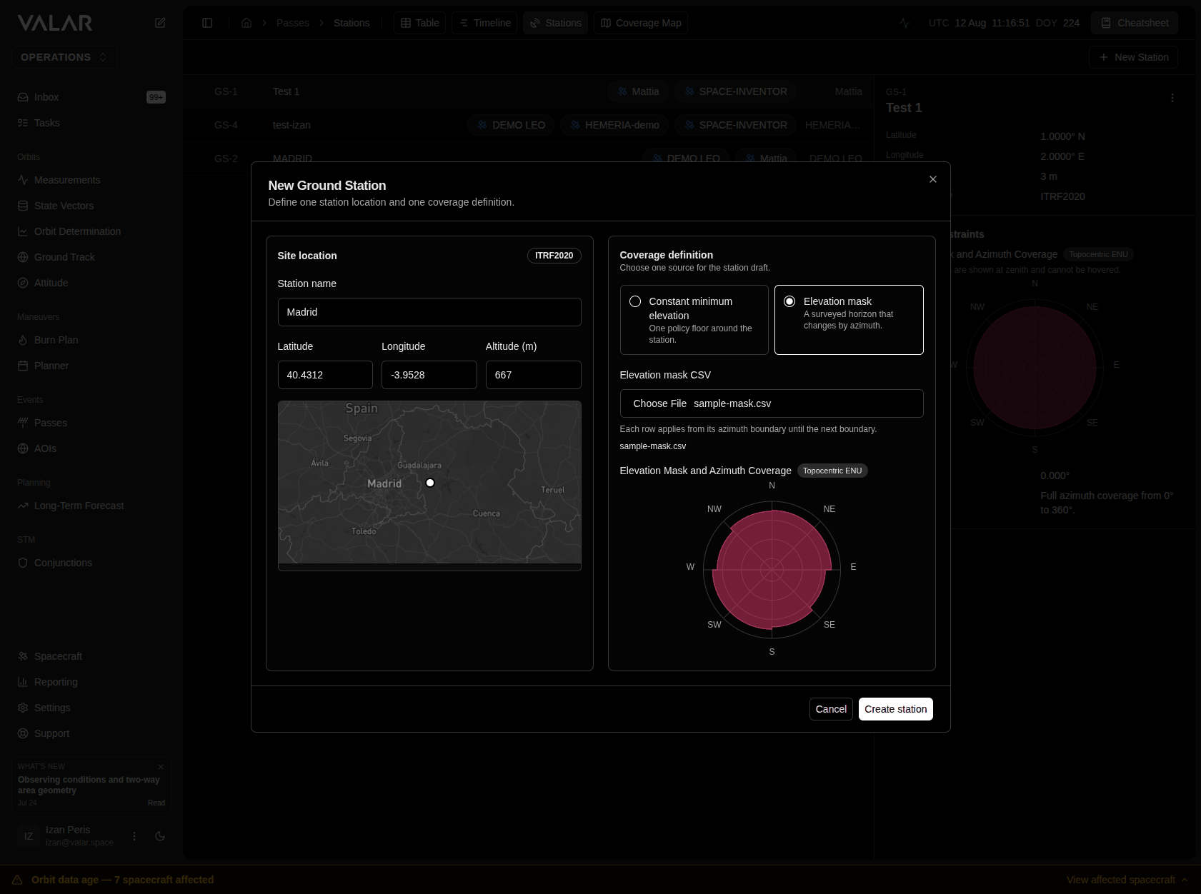 Below the coverage controls, a radar-style chart shows the **applied horizon** — the server-evaluated result of your coverage definition, redrawn shortly after you stop typing or a file finishes uploading. This is the same interpretation the platform uses to compute passes; you review the result rather than calculating it yourself.
The minimum elevation value carries over as a floor beneath an elevation mask too: for any azimuth where the mask specifies a lower elevation than the current minimum-elevation value, the higher of the two is what the preview (and the saved station) actually applies. If you intend a mask value to take effect exactly as surveyed, make sure the minimum elevation is set at or below it.
| Situation | What you see |
| ------------------------------------------------------------------------- | ---------------------------------------------------------------------------------------------------------------------------------------------- |
| **Nothing entered yet** | **Enter a coverage definition to preview the applied horizon.** |
| **A value just changed and the new preview hasn't returned yet** | The previous chart dims and reads **Preview is out of date**. |
| **The preview request is in flight** | A loading placeholder replaces the chart — no stale result is shown as current. |
| **The server cannot evaluate the current draft** | **Horizon could not be evaluated**, with guidance to adjust the minimum elevation or the uploaded survey. Saving is blocked until this clears. |
| **Constant minimum elevation, valid** | A uniform circle at the chosen elevation. |
| **Elevation mask, valid** | A shape that varies by azimuth, reflecting the uploaded survey (composed with the minimum-elevation floor above). |
| **Editing an existing station whose stored profile can't be interpreted** | **Applied horizon unavailable** — every other field on the station stays editable regardless. |
### Validation
Every field is checked as you type; a required field only shows as missing after you attempt to save.
| Field | Error shown |
| ------------------------------- | ------------------------------------------------------------------------------ |
| **Station name** | Enter a station name |
| **Latitude** | Enter a latitude / Latitude must be between -90 and 90 degrees |
| **Longitude** | Enter a longitude / Longitude must be between -180 and 180 degrees |
| **Altitude (m)** | Enter an altitude / Altitude must be a number |
| **Minimum elevation (degrees)** | Enter a minimum elevation / Minimum elevation must be between 0 and 90 degrees |
If saving fails after every field validates, the modal stays open, every value you entered is preserved, and a banner explains what went wrong so you can retry without re-entering anything.
Click **Cancel** to close without saving, or **Create station** (**Save changes** when editing) to save. The button reads **Saving...** while the request is in flight.
## Editing or Deleting a Station
Select a station in the list, open its kebab menu (**⋮**), and choose **Edit Station** to reopen the same modal pre-filled with that station's values, or **Delete Station** to remove it. Deleting asks you to confirm first — **Are you sure you want to delete \? This action cannot be undone.**
## Related Pages
* [Passes Overview](/features/passes/overview) — the Passes area's landing page and a map of where each Passes page fits.
* [Elevation Masks](/features/passes/elevation-masks) — what a station's elevation mask is and how it combines with its minimum elevation.
* [Timeline](/features/passes/timeline) — what each station's outcome on the timeline means, including what to do about it.
* [Coverage Map](/features/passes/coverage-map) — a read-only geographic view of every station's coverage footprint at a shared reference altitude.
Below the coverage controls, a radar-style chart shows the **applied horizon** — the server-evaluated result of your coverage definition, redrawn shortly after you stop typing or a file finishes uploading. This is the same interpretation the platform uses to compute passes; you review the result rather than calculating it yourself.
The minimum elevation value carries over as a floor beneath an elevation mask too: for any azimuth where the mask specifies a lower elevation than the current minimum-elevation value, the higher of the two is what the preview (and the saved station) actually applies. If you intend a mask value to take effect exactly as surveyed, make sure the minimum elevation is set at or below it.
| Situation | What you see |
| ------------------------------------------------------------------------- | ---------------------------------------------------------------------------------------------------------------------------------------------- |
| **Nothing entered yet** | **Enter a coverage definition to preview the applied horizon.** |
| **A value just changed and the new preview hasn't returned yet** | The previous chart dims and reads **Preview is out of date**. |
| **The preview request is in flight** | A loading placeholder replaces the chart — no stale result is shown as current. |
| **The server cannot evaluate the current draft** | **Horizon could not be evaluated**, with guidance to adjust the minimum elevation or the uploaded survey. Saving is blocked until this clears. |
| **Constant minimum elevation, valid** | A uniform circle at the chosen elevation. |
| **Elevation mask, valid** | A shape that varies by azimuth, reflecting the uploaded survey (composed with the minimum-elevation floor above). |
| **Editing an existing station whose stored profile can't be interpreted** | **Applied horizon unavailable** — every other field on the station stays editable regardless. |
### Validation
Every field is checked as you type; a required field only shows as missing after you attempt to save.
| Field | Error shown |
| ------------------------------- | ------------------------------------------------------------------------------ |
| **Station name** | Enter a station name |
| **Latitude** | Enter a latitude / Latitude must be between -90 and 90 degrees |
| **Longitude** | Enter a longitude / Longitude must be between -180 and 180 degrees |
| **Altitude (m)** | Enter an altitude / Altitude must be a number |
| **Minimum elevation (degrees)** | Enter a minimum elevation / Minimum elevation must be between 0 and 90 degrees |
If saving fails after every field validates, the modal stays open, every value you entered is preserved, and a banner explains what went wrong so you can retry without re-entering anything.
Click **Cancel** to close without saving, or **Create station** (**Save changes** when editing) to save. The button reads **Saving...** while the request is in flight.
## Editing or Deleting a Station
Select a station in the list, open its kebab menu (**⋮**), and choose **Edit Station** to reopen the same modal pre-filled with that station's values, or **Delete Station** to remove it. Deleting asks you to confirm first — **Are you sure you want to delete \? This action cannot be undone.**
## Related Pages
* [Passes Overview](/features/passes/overview) — the Passes area's landing page and a map of where each Passes page fits.
* [Elevation Masks](/features/passes/elevation-masks) — what a station's elevation mask is and how it combines with its minimum elevation.
* [Timeline](/features/passes/timeline) — what each station's outcome on the timeline means, including what to do about it.
* [Coverage Map](/features/passes/coverage-map) — a read-only geographic view of every station's coverage footprint at a shared reference altitude.