
For the complete documentation index, see llms.txt.Click New AOI in the top bar from either the AOI Overview or AOI Map page to start creating an AOI. The button always lands you on the AOI Map first, then opens a method picker so you choose how to define the geometry: by drawing on the map, by typing coordinates into a form, or by pasting a GeoJSON document. Save persists the AOI; an automatic recompute fires once you save so the events forecast populates immediately. Route: Opened from the New AOI button on the AOI Overview page or the AOI Map page. Clicking the button from either page navigates to
/aoi/map first and then opens the method picker.
Method Picker
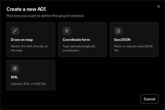
Click a card to pick the method; the picker closes and the corresponding creation surface opens. Click Cancel, click outside the modal, or press Escape to dismiss the picker without choosing.
Draw on Map
Picking Draw on map keeps you on the AOI Map and surfaces a floating toolbar in the top-left corner of the canvas. The toolbar segments are:
A helper text reading
Draw a shape on the map to continue renders beneath the toolbar until the shape is complete.
Once you finish the shape, a small popover anchors at the top-right corner of the map with the AOI form (described below). The shape stays visible on the map and updates live when you adjust fields.
Coordinate Form
Picking Coordinate form opens the AOI form in a centered modal dialog headed New AOI — Coordinate form. As you type vertices, a dashed sky-blue preview of the shape renders on the world map behind the dialog so you can sanity-check the geometry against the basemap. The geometry editor at the top of the form lets you pick the primitive (Polygon, Disk, or Multipolygon) and enter the structured fields:
A polygon with fewer than 3 vertices surfaces
Add at least 3 vertices to continue and disables Save until the geometry is valid. The form caps each polygon at 100 vertices.
GeoJSON
Picking GeoJSON opens the AOI form in a centered modal dialog headed New AOI — GeoJSON. A textarea + file picker at the top accepts your GeoJSON; the live preview on the map behind the dialog updates as soon as the document parses.
While the textarea is empty, a helper line reads
Paste valid GeoJSON to continue. While a parse fails, the helper reads GeoJSON must be a Polygon, Disk, or MultiPolygon. While a file is too large, the helper reads GeoJSON file must be 1 MB or smaller. See the GeoJSON file format page for the supported RFC 7946 subset.
KML
Picking KML opens the AOI form in a centered modal dialog headed New AOI — KML. Unlike the GeoJSON flow there is no paste box — KML areas (and especially.kmz archives) are file-based, so the KML card is upload-only.
Click Upload .kml or .kmz file to open the file picker; it accepts .kml and .kmz files. VALAR reads a single area from the file and previews it on the map behind the dialog, editable just like a drawn or GeoJSON-imported area. Before you choose a file, a muted helper reads Select a .kml or .kmz file and Save stays disabled.
The KML file’s own name, description, and styling are ignored — you name and colour the AOI in the form below, exactly as for the other methods. If a file cannot be imported, an inline red message on the card explains why (see Validation Errors). The full catalogue of accepted geometry, what is silently dropped, the size limits, and each error meaning lives on the KML and KMZ file format page.
Shared Form Fields
Regardless of the creation method, every AOI form surfaces the same sections beneath the geometry block.Identity
Lifecycle
The create form is paired — leave both bounds empty for an always-active AOI, or set both together. To produce a one-bound (open-ended) window, create the AOI without bounds, then edit it via the dialog on the AOI Overview page, which exposes a per-bound Set / Open-ended switch.
Validation Errors
The form validates input inline before letting you Save. The error strings are surfaced verbatim:Saving and Cancelling
Click Save to create the AOI. The button reads Saving… while the request is in flight. On success the form closes, the new AOI is selected on the map, and an automatic recompute fires so the events forecast populates immediately. If the save rejects, an inline banner above the form readsCouldn't save AOI — try again; the banner clears the moment you edit any field.
Click Cancel to discard the draft. If you have unsaved changes, a confirmation dialog Discard changes appears with the body Discard your changes? Your edits will be lost. Choose Keep editing to return to the form or Discard to close it. A non-dirty cancel routes straight to the closing transition.
Editing an Existing AOI
To edit an existing AOI, open the AOI Overview page, select the AOI, and click the pen icon in the identity hero to enter edit mode. Identity fields become inline-editable; the validity window opens an edit dialog from the geometry block. The full editing workflow — including the kebab actions for Set active, Set inactive, and Delete AOI — is documented on the Overview page. Editing the geometry, the validity window, or the Active flag automatically triggers a recompute. Editing only identity fields (name, description, tags, colour) does not trigger a recompute; existing events stay in the list.Deleting an AOI
Deletion is initiated from the kebab menu in the identity hero on the AOI Overview page, or from the kebab menu on a hovercard on the AOI Map page. Both paths surface a Delete AOI confirmation dialog; click Delete to confirm or Cancel to keep the AOI. After deletion the page navigates to the next remaining AOI, or to the empty state if it was the only one.Related Pages
- Areas of Interest overview — read and edit an existing AOI in depth.
- AOI Map — the world map where every creation flow begins.
- Overflight events — the 7-day forecast that follows every AOI save.
- GeoJSON file format — the supported RFC 7946 subset accepted by the GeoJSON flow.
- KML and KMZ file format — the KML / KMZ geometry accepted by the KML flow.