
For the complete documentation index, see llms.txt.The AOI Map is a full-bleed world map that plots every Area of Interest in the workspace. Use it to see your AOIs in their geographic context, click any shape to open a compact summary hovercard, and start a new AOI from the same surface. The map shares the top bar and the right-docked AOI list with the AOI Overview page so navigating between the two routes is seamless. Route:
/aoi/map
Open the page via the AOIs entry in the sidebar, then switch to the map view, or click any New AOI button anywhere in the AOI surface — that button always lands you on the map first.
Page Layout
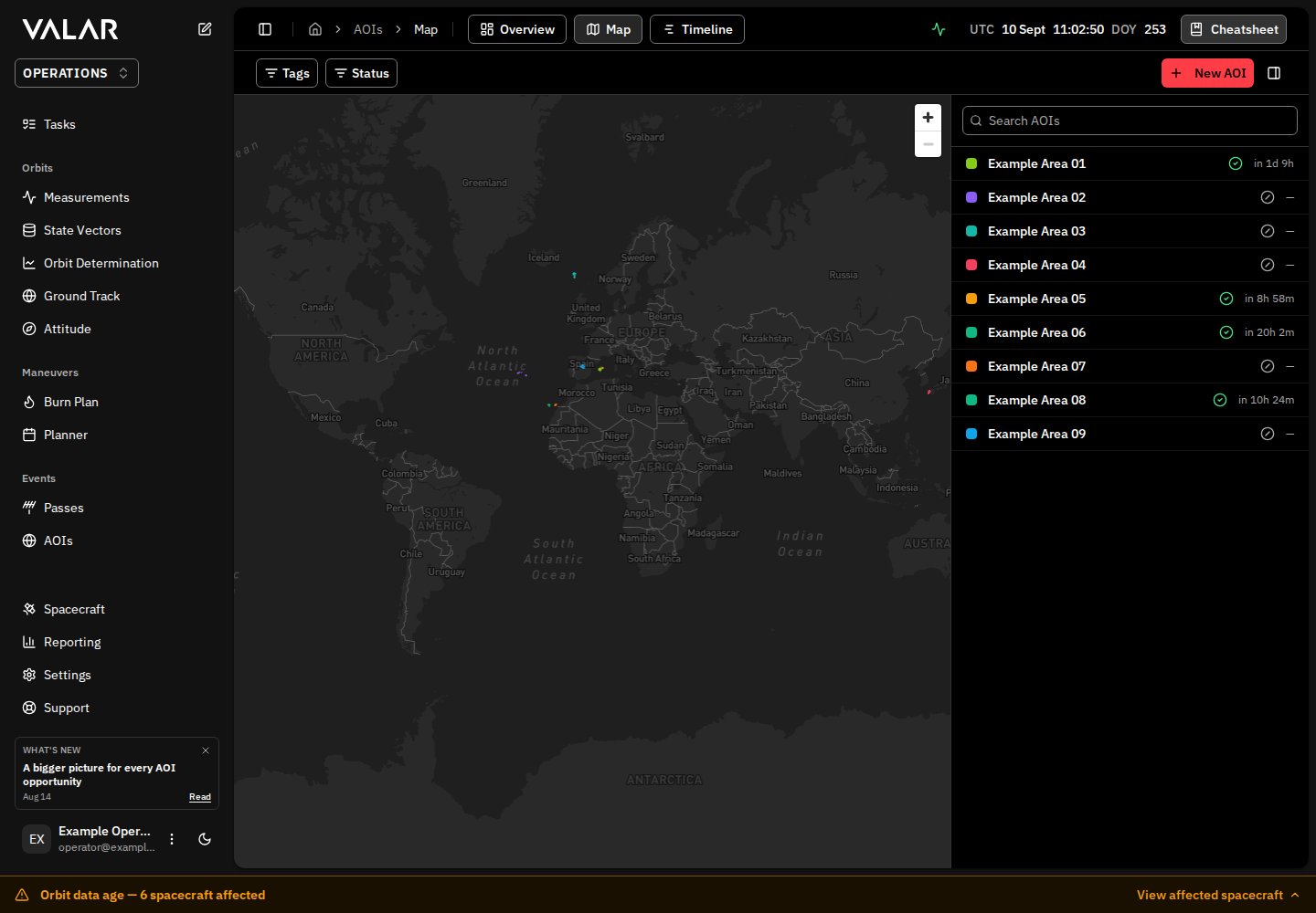
The map respects your light / dark theme, and the camera opens at a full-world view. Drag to pan; scroll or pinch to zoom; click the zoom buttons in the top-right corner for click-driven zoom. The camera is clamped to the WGS84 world envelope so pan cannot wrap the globe.
When your browser does not support WebGL or the map is otherwise unavailable, the canvas is replaced by a fallback element reading
Map unavailable — couldn't load in this browser.
AOI Shapes on the Map
Every AOI in the workspace renders as a filled shape on the basemap, painted in the AOI’s chosen palette colour. Hovering a shape thickens its outline and switches the cursor to a pointer. Clicking the shape selects the AOI:- The URL updates to
/aoi/map?selected=<id>so the selection survives reloads. - The shape’s outline thickens and the fill darkens slightly so the active AOI reads clearly against the basemap.
- A hovercard opens, anchored to the centroid of the shape, summarising the AOI and its next overflights.
?selected=<id> value restores the selected AOI. If the value is bogus or no longer identifies an available AOI, selection falls back to another available AOI instead of leaving the surface without a selection.
When the workspace has no AOIs, the canvas surfaces a single floating banner reading No AOIs yet — click + New AOI to create one.
AOI Hovercard
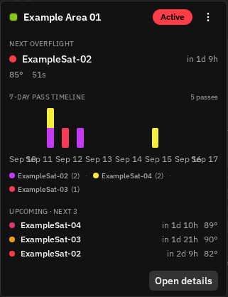
The hovercard closes when you click outside it, press Escape, or click the colour-swatch shape again.
Kebab Menu Actions
The kebab menu in the hovercard offers three actions:
After deletion the shape disappears from the map and the hovercard closes. A toast confirms
AOI was deleted.
Creating an AOI From the Map
Click New AOI in the top bar (or Create your first AOI on the empty-workspace list pane) to start the creation flow. The button drops you into the method picker described on the Create an AOI page; the map stays visible behind the picker so you keep your geographic reference. The three methods route to different surfaces on this same map:- Draw on map — a floating toolbar appears in the top-left corner. Draw the shape directly on the canvas; once the shape is complete, a compact form anchors at the top-right corner of the map. Save the AOI and the new shape stays plotted on the map, selected, with its hovercard open.
- Coordinate form — a centered modal dialog opens. As you type vertices (or centre + radius for a disk), a dashed sky-blue preview of the geometry renders live on the map behind the dialog.
- GeoJSON — a centered modal dialog opens with a textarea + file picker. As you paste or upload GeoJSON, the dashed live preview updates on the map behind the dialog.
Couldn't save AOI — try again. The banner clears the moment you edit any field. Cancelling a dirty form opens a confirmation dialog Discard changes with the body Discard your changes? Your edits will be lost. — choose Keep editing to keep the form open, or Discard to close it.
Shared Top Bar and List Pane
The top bar and the right-docked AOI list pane are identical to those on the AOI Overview page:- The Tags and Status filters in the top bar narrow the AOIs listed in the right pane. They do not hide shapes on the map — every AOI in the workspace is always plotted.
- The list pane carries its own Search AOIs input that filters the rows the pane renders.
- The collapse toggle at the right edge of the top bar hides the list pane so the map takes the full page width. Click it again to bring the list back.
Reference Frame
AOI shapes are defined by WGS84 geodetic coordinates (latitude / longitude on the WGS84 ellipsoid) and rendered on a Mercator basemap. Coordinates surfaced in the hovercard, the geometry properties, and the per-event detail use the same frame.Related Pages
- Areas of Interest overview — read and edit one AOI in depth, including the inline-edit affordances in the identity hero and the validity-window edit dialog in the geometry block.
- Create an AOI — the full reference for the Draw / Coordinate form / GeoJSON creation flows.
- Overflight events — the per-event detail panel and the recompute mechanics that sit behind every AOI’s events forecast.
- GeoJSON file format — accepted geometry types for AOIs created from a GeoJSON document.